-
Featured Archive fires for Indonesia
The Fire Information for Resource Management System (FIRMS) delivers global MODIS-derived hotspots and fire locations. The active fire locations represent the center of a 1-kilometer pixel that is flagged by the MOD14/MYD14 Fire and Thermal Anomalies Algorithm as containing one or more fires...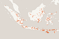
-
CAIT Indonesia Climate Data Explorer (PINDAI) Data
The data set draws primarily from Local Action Plan for Greenhouse Gas Emission Reduction (RAD GRK), and Medium Term Local Development Plans (RPJMD) of each province in Indonesia. These documents are obtained from Indonesian national and regional government agencies, including the Secretariat of...
-
Digital Globe GEO1 Satellite Imagery
Effective emergency planning and response requires quick and easy access to accurate, up-to-date information. DigitalGlobe’s FirstLook is an online subscription service for emergency management that provides fast web-based access to pre-and post-event imagery of world disasters delivered to...
-
Digital Globe QB01 Satellite Imagery
Effective emergency planning and response requires quick and easy access to accurate, up-to-date information. DigitalGlobe’s FirstLook is an online subscription service for emergency management that provides fast web-based access to pre-and post-event imagery of world disasters delivered to...
-
Digital Globe WV01 Satellite Imagery
Effective emergency planning and response requires quick and easy access to accurate, up-to-date information. DigitalGlobe’s FirstLook is an online subscription service for emergency management that provides fast web-based access to pre-and post-event imagery of world disasters delivered to...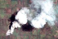
-
Aqueduct Global Flood Risk Country Rankings
Key Findings Approximately, 21 million people worldwide could be affected by river floods on average each year, and the 15 countries with the most people exposed, including India, Bangladesh, China, Vietnam, Pakistan, Indonesia, Egypt, Myanmar, Afghanistan, Nigeria, Brazil, Thailand, Democratic...
-
Marine Protected Areas in Coral Reef Regions of the World
This dataset is part of the base data used for Reefs at Risk Revisited. To assess the level of protection and management for coral reefs around the world. The map of MPAs and associated management effectiveness scores were used to adjust pressure from overfishing and destructive fishing in the...