-
Featured Dataset of Electric School Bus Adoption in the United States
Transitioning to electric school buses (ESBs) from traditional diesel-powered school buses can reduce students’ exposure to air pollution and decrease greenhouse gas emissions. School districts and private fleet operators around the United States are adopting electric school buses with increasing...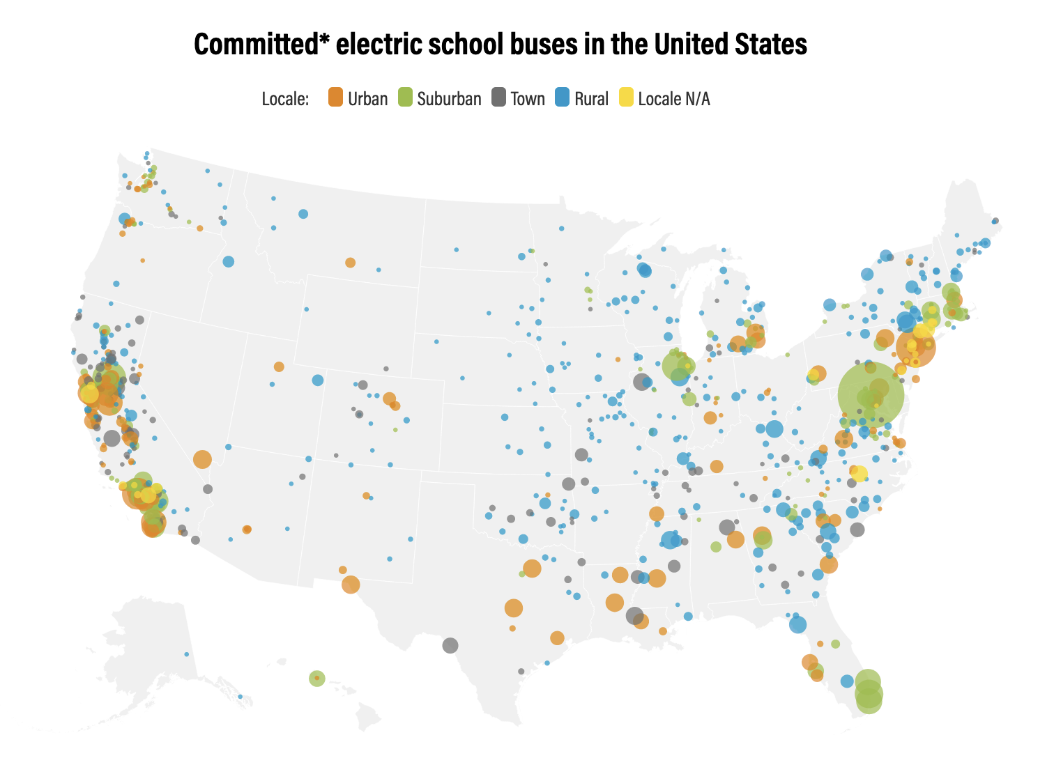
-
Tropical Coral Reefs of the World (500-m resolution grid)
Global map of shallow, tropical coral reefs, gridded at 500-m resolution for use in the Reefs at Risk Revisited project. The coral reef location data were compiled from multiple sources by UNEP-WCMC, the WorldFish Center, and WRI. To standardize these data for the purposes of the Reefs at Risk...
-
Kenya Shaded Relief Surface (90m resolution)
The cell values represent illumination value from 0 - 255. Shaded relief surfaces are mainly used as background in mapping and displaying data. [RETURN] This spatial data set is a derivative product of the Shuttle Radar Topography Mission(SRTM) digital elevation model(DEM) data set. The SRTM DEM...
-
Basins and sub-basins in Kenya
Calculations done by the World Resources Institute. This data was used in selected maps in Nature's Benefits in Kenya: An Atlas of Ecosystems and Human Well-Being.
-
Existing small-scale irrigation and drainage points in Kenya
Data compiled by the International Water Management Institute (IWMI), Nairobi, Kenya. This data was used in Map 3.12 in Nature's Benefits in Kenya: An Atlas of Ecosystems and Human Well-Being.
-
Wetlands in Kenya
This data was used in selected maps in Nature's Benefits in Kenya: An Atlas of Ecosystems and Human Well-Being. Original data are downloadable at www.africover.org.
-
Urban areas in Kenya
This data was used in Map 1.3 and in other maps throughout Nature's Benefits in Kenya: An Atlas of Ecosystems and Human Well-Being. Original data are downloadable at www.africover.org.
-
Locations of sand beaches in Kenya
This data was used in Map 6.4 and Map 6.5 in Nature's Benefits in Kenya: An Atlas of Ecosystems and Human Well-Being. Original data are downloadable at www.africover.org.
-
Savannah and grassland in Kenya
This data was used in Map 1.3 in Nature's Benefits in Kenya: An Atlas of Ecosystems and Human Well-Being. Original data are downloadable at www.africover.org.
-
Forest Types in Kenya, 2000
This data was used in Map 1.3 and Map 7.1 in Nature's Benefits in Kenya: An Atlas of Ecosystems and Human Well-Being. Original data are downloadable at www.africover.org.
-
Floodplains and valley bottoms in Kenya
This data was used in Map 3.14 and Map 3.15 in Nature's Benefits in Kenya: An Atlas of Ecosystems and Human Well-Being. Original data are downloadable at www.africover.org.
-
Bare areas (areas naturally devoid of vegetation) in Kenya
This data was used in Map 1.3 in Nature's Benefits in Kenya: An Atlas of Ecosystems and Human Well-Being. Original data are downloadable at www.africover.org.
-
Locations of sable antelope sites, Kenya
This data was used in Map 6.4 and Map 6.5 in Nature's Benefits in Kenya: An Atlas of Ecosystems and Human Well-Being. Original data and report are downloadable at http://www.unep.org/eafatlas/dbke.htm.
-
Waterbodies in Kenya
This data was used in maps throughout Nature's Benefits in Kenya: An Atlas of Ecosystems and Human Well-Being. Original data are downloadable at www.africover.org.
-
Permanent and Non-Permanent Rivers in Kenya
This data was used in maps featured in Natures Benefits in Kenya: An Atlas of Ecosystems and Human Well-Being. Original data are available at http://mapping.usgs.gov/esic/cdrom/vmap.html.
-
Pineapple Plantations in Kenya
This data was used in Map 3.9 in Nature's Benefits in Kenya: An Atlas of Ecosystems and Human Well-Being. Original data are downloadable at www.africover.org.
-
Large-Scale Irrigation in Kenya
This data was used in Map 3.12 in Nature's Benefits in Kenya: An Atlas of Ecosystems and Human Well-Being. Original data are downloadable at www.africover.org.
-
Agricultural Areas in Kenya
This data was used in Map 1.3 in Nature's Benefits in Africa: An Atlas of Ecosystems and Human Well-Being. Original data are downloadable at www.africover.org.
-
Kenya Important Bird Areas (IBAs) and their Status, 2003-04
This data was used in Map 5.3 in Nature's Benefits in Kenya: An Atlas of Ecosystems and Human Well-Being. Please note that this data is frequently updated. Please refer to Birdlife International's website for most updated versions and downloads: http://www.birdlife.org/datazone/index.html
-
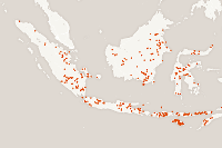
Featured Archive fires for Indonesia
The Fire Information for Resource Management System (FIRMS) delivers global MODIS-derived hotspots and fire locations. The active fire locations represent the center of a 1-kilometer pixel that is flagged by the MOD14/MYD14 Fire and Thermal Anomalies Algorithm as containing one or more fires...