-
Indicators of Sustainable Agriculture: A Scoping Analysis
The spreadsheet “Evaluation of Candidate Indicators of Environmental Sustainability of Agriculture” presents the complete list of candidate indicators that were considered in the scoping analysis as well as the results of an assessment that determined the suitability of these candidate indicators...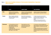
-
Percent Treecover in Kenya
The Vegetation Continuous Fields (VCF) collection contains proportional estimates for vegetative cover types: woody vegetation, herbaceous vegetation, and bare ground. The product is derived from all seven bands of the MODerate-resolution Imaging Spectroradiometer (MODIS) sensor onboard NASA's...
-
Kenya Digital Elevation Model (90m resolution)
The objective of the SRTM mission is to obtain elevation radar data on a near-global scale and generate the most complete high-resolution digital topographic database of the Earth. The information collected by SRTM will be used to provide a tool to enhance the activities of scientists, the...
-
Local Government Renewables Action Tracker
The Tracker contains information on two types of renewables activities commonly being pursued by local governments in the United States: 1. Electricity purchases and transactions, such as on-site solar, community solar projects, off-site power purchase agreements (PPAs), and green tariff...