-
Milk Production Per Square Kilometer in Kenya, 1997
This data was used in Map 4.5 in Nature's Benefits in Kenya: An Atlas of Ecosystems and Human Well-Being.
-
Aqueduct Global Flood Risk Country Rankings
Key Findings Approximately, 21 million people worldwide could be affected by river floods on average each year, and the 15 countries with the most people exposed, including India, Bangladesh, China, Vietnam, Pakistan, Indonesia, Egypt, Myanmar, Afghanistan, Nigeria, Brazil, Thailand, Democratic...
-
NWIS 1997 Data (Uganda)
Some data were used in maps 4, 5, 6, 7, 8, 9, 10 of ""Mapping a Better Future: How Spatial Analysis Can Benefit Wetlands and Reduce Poverty in Uganda."" from Wetlands Management Department, Ministry of Water and Environment, Uganda; Uganda Bureau of Statistics; International Livestock Research...
-
Featured RSPO Palm Oil Mills
Certification of sustainable palm oil production is handled through the palm oil mill and its supply base. The certification includes plantations managed by the mill and plantations managed by other suppliers, including smallholders. To have its oil mill certified, a palm oil producer must show a...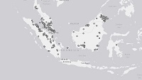
-
Digital Globe WV01 Satellite Imagery
Effective emergency planning and response requires quick and easy access to accurate, up-to-date information. DigitalGlobe’s FirstLook is an online subscription service for emergency management that provides fast web-based access to pre-and post-event imagery of world disasters delivered to...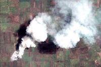
-
Featured Global Power Plant Database
The Global Power Plant Database is a comprehensive, open source database of power plants around the world. It centralizes power plant data to make it easier to navigate, compare and draw insights for one’s own analysis. The database covers approximately 35,000 power plants from 167 countries and...
-
Annual Growth of Biomass and Theoretically Harvestable Biomass Yield outside ...
This data was used in Map 7.6 and Map 7.7 in Nature's Benefits in Kenya: An Atlas of Ecosystems and Human Well-Being. Values of zero for both fields pertain to croplands and urban areas, and should be displayed as ""not applicable."" Note: All areas classified as 'natural and semi-natural' in...
-
Sarawak oil palm concessions
This data set provides the boundaries of known oil palm concessions for the state of Sarawak, Malaysia, and was compiled from available public documents. Where available, associated information provided with this data set includes licensee name, permit number (Operational Ticket), corporate...
-
Digital Globe GEO1 Satellite Imagery
Effective emergency planning and response requires quick and easy access to accurate, up-to-date information. DigitalGlobe’s FirstLook is an online subscription service for emergency management that provides fast web-based access to pre-and post-event imagery of world disasters delivered to...
-
Digital Globe QB01 Satellite Imagery
Effective emergency planning and response requires quick and easy access to accurate, up-to-date information. DigitalGlobe’s FirstLook is an online subscription service for emergency management that provides fast web-based access to pre-and post-event imagery of world disasters delivered to...
-
Climate Watch (CAIT) - UNFCCC Annex I GHG Emissions Data
The CAIT Paris Contributions Map was made available in 2014 to enables users to explore, compare, and assess countries climate committments in each country's Intended Nationally Determined Contributions (INDC). Countries are not submitting and updating their national climate committments through...
-
Featured Climate Watch – Nationally Determined Contributions (NDC) Data (previously CA...
The CAIT Paris Contributions Map was made available in 2014 to enables users to explore, compare, and assess countries climate commitments in each country's Intended Nationally Determined Contributions (INDC). Countries are not submitting and updating their national climate commitments through...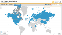
-
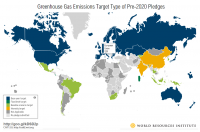
CAIT - Countries' Pre-2020 Climate Pledges submitted to the UNFCCC
The structured data from the CAIT Pre-2020 Pledges Map enables users to explore, compare, and assess climate change mitigation pledges submitted by Parties to the United Nations Framework Convention on Climate Change (UNFCCC) in 2009 and 2010. The information related to quantified economy-wide...