-
Featured Dataset of Electric School Bus Adoption in the United States
Transitioning to electric school buses (ESBs) from traditional diesel-powered school buses can reduce students’ exposure to air pollution and decrease greenhouse gas emissions. School districts and private fleet operators around the United States are adopting electric school buses with increasing...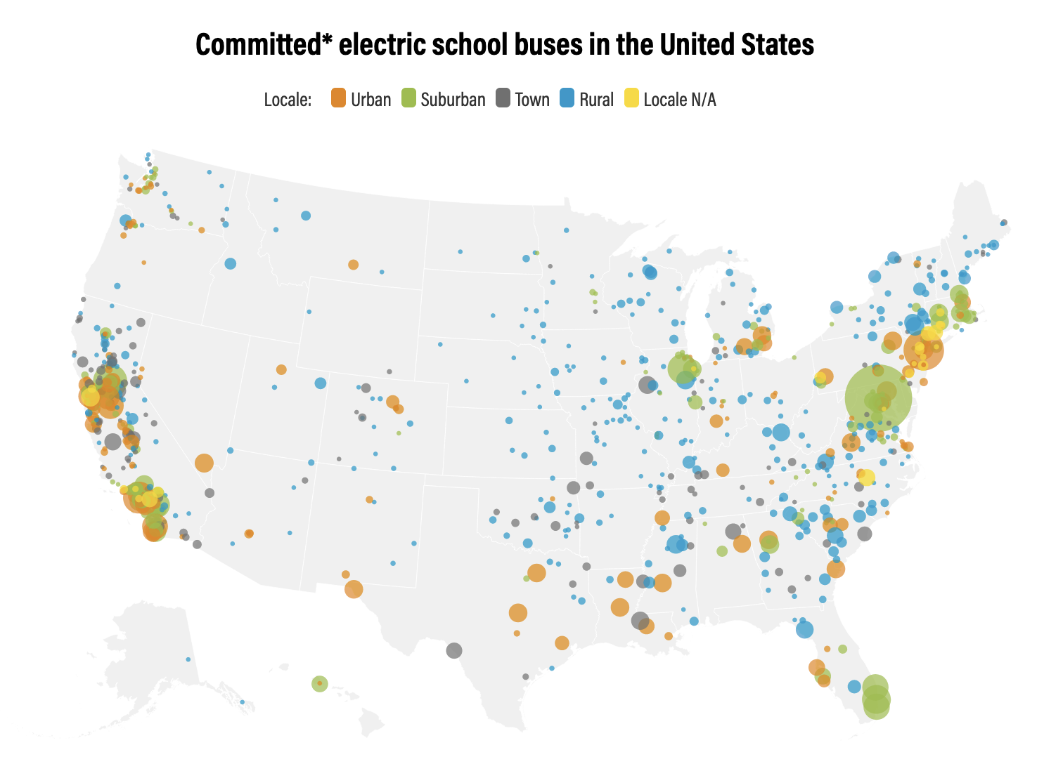
-
Climate Watch - U.S. States Greenhouse Gas Emissions
Climate Watch Historical GHG Emissions module enables data analysis by allowing users to quickly narrow down by year, gas, state, and sector. Automatic calculations for percent changes from prior year, per capita, per GDP, and cumulative number across years are also available. Users are presented...
-
Dataset of U.S. School Bus Fleets
This dataset contains detailed information on the composition of school bus fleets in the United States. It dataset contains data from 46 states and the District of Columbia, though the specific data available vary by state. For most states, the dataset includes bus-level information, such as the...
-
Local Government Renewables Action Tracker
The Tracker contains information on two types of renewables activities commonly being pursued by local governments in the United States: 1. Electricity purchases and transactions, such as on-site solar, community solar projects, off-site power purchase agreements (PPAs), and green tariff...
-
Distance to water points in northern Kenya
This data was used in Map 5.8 and Map 5.9 in Nature's Benefits in Kenya: An Atlas of Ecosystems and Human Well-Being. Use attribute field VALUE to display data. Units are in kilometers. 0 = 0 kilometers from nearest water point 5 = 0.1 - 5 kilometers from nearest water point 10 = 5 -...
-
Permanent and Non-Permanent Rivers in Kenya
This data was used in maps featured in Natures Benefits in Kenya: An Atlas of Ecosystems and Human Well-Being. Original data are available at http://mapping.usgs.gov/esic/cdrom/vmap.html.
-
Major Airfields in Kenya
This data was used in Map 6.4 and Map 6.5 featured in Natures Benefits in Kenya: An Atlas of Ecosystems and Human Well-Being.
-
Wildlife density in Kenya's rangelands: 1994-96
This data was used in Map 1.4, Map 4.10, and Map 5.11 in Nature's Benefits in Kenya: An Atlas of Ecosystems and Human Well-Being. Species numbers are aggregated using a ""tropical livestock unit"" (TLU) (which is equivalent to an animal weight of 250 kilograms) to grid cells of 5x5 km and then...
-
Livestock density in Kenya's rangelands, 1994-1996
This data was used in Map 1.5 and Map 4.7 in Nature's Benefits in Kenya: An Atlas of Ecosystems and Human Well-Being. Species numbers are aggregated using a ""tropical livestock unit"" (TLU) (which is equivalent to an animal weight of 250 kilograms) to grid cells of 5x5 km and then averaged by...
-
Floodplains and valley bottoms in Kenya
This data was used in Map 3.14 and Map 3.15 in Nature's Benefits in Kenya: An Atlas of Ecosystems and Human Well-Being. Original data are downloadable at www.africover.org.
-
Coral reefs in Kenya
This data was used in Map 6.4 and Map 6.5 in Nature's Benefits in Kenya: An Atlas of Ecosystems and Human Well-Being. The full report is available at http://www.geus.dk/program-areas/nature-environment/international/reports/kensea/kensea_rapport.pdf.
-
Locations of sable antelope sites, Kenya
This data was used in Map 6.4 and Map 6.5 in Nature's Benefits in Kenya: An Atlas of Ecosystems and Human Well-Being. Original data and report are downloadable at http://www.unep.org/eafatlas/dbke.htm.
-
Size of Agricultural Crops in Kenya
Used in Map 5.7 of Nature's Benefits in Kenya: An Atlas of Ecosystems and Human Well-Being. Original data are downloadable at www.africover.org.
-
Percent of Land under Cultivation in Kenya
Used in Map 5.4 of Nature's Benefits in Kenya: An Atlas of Ecosystems and Human Well-Being.Original data are downloadable at www.africover.org.
-
CAIT - Country Clean Technology Data
This collection emerges from a collaboration of five leading research institutions: World Resources Institute (WRI), Institute for Global Environmental Strategies (IGES), Öko Institut, Renmin University, and The Energy and Resources Institute (TERI), based in the target countries. Researchers at...
-
Eutrophication & Hypoxia Map Data Set
The Interactive Map of Eutrophication & Hypoxia represents 762 coastal areas impacted by eutrophication and/or hypoxia. There are 479 sites identified as experiencing hypoxia, 55 sites that once experienced hypoxia but are now improving, and 228 sites that experience other symptoms of...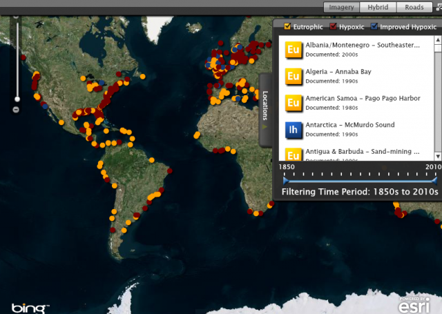
-
Percent woodlots in sampled cropland in Kenya
This data was used in Map 7.3 in Nature's Benefits in Kenya: An Atlas of Ecosystems and Human Well-Being. These data combine detailed crop information from 5,747 aerial photos for a growing season in 1997, each providing a sample point of detailed crop information. These samples were averaged...
-
Percentage Food Crops in Central and Western Kenya
World Agroforestry Center (ICRAF) and Department of Resource Surveys and Remote Sensing (DRSRS), Ministry of Environment and Natural Resources. 2001. GIS Database of Land Use and Land Cover for Kenya's Medium to High Potential Districts. DRSRS interpretation of 5,747 aerial photographs from...
-
Average number of crops grown in croplands of central and western Kenya, 1997
World Agroforestry Center (ICRAF) and Department of Resource Surveys and Remote Sensing (DRSRS), Ministry of Environment and Natural Resources. 2001. GIS Database of Land Use and Land Cover for Kenya's Medium to High Potential Districts. DRSRS interpretation of 5,747 aerial photographs from...
-
Tourist Accommodations in Kenya
Approximately placed by ILRI/WRI based on MacMillan Education Ltd. 1993, UNEP/GRID-Nairobi 1998, and RoK 1998