-
Digital Globe WV01 Satellite Imagery
This data set provides the boundaries of known oil palm concessions for the state of Sarawak, Malaysia, and was compiled from available public documents. Where available, associated information provided with this data set includes licensee name, permit number (Operational Ticket), corporate...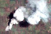
-
Digital Globe QB01 Satellite Imagery
Effective emergency planning and response requires quick and easy access to accurate, up-to-date information. DigitalGlobe’s FirstLook is an online subscription service for emergency management that provides fast web-based access to pre-and post-event imagery of world disasters delivered to...