-
Population density of Kenya, 1989
This data was used in Map 2.4 (Chapter 2) in Natures Benefits in Kenya: An Atlas of Ecosystems and Human Well-Being.
-
Sources of wood for charcoal in selected administrative Districts in Kenya, 2004
This data was used in Map 7.5 in Nature's Benefits in Kenya: An Atlas of Ecosystems and Human Well-Being.
-
Featured Intact Forest Landscapes (2013)
"The Intact Forest Landscapes (IFL) data set identifies unbroken expanses of natural ecosystems within the zone of forest extent that show no signs of significant human activity and are large enough that all native biodiversity, including viable populations of wide-ranging species, could be...
-
Uganda District Boundaries 2006
Contact Uganda Bureau of Statistics for an updated version of district boundaries Note that data collection took place from July 1999 to March 2002. The data were updated in 2006.
-
Featured Protected areas
The World Database on Protected Areas (WDPA) is the most comprehensive global spatial data set on marine and terrestrial protected areas available. Protected area data are provided via Protected Planet, the online interface for the World Database on Protected Areas (WDPA). The WDPA is a joint...
-
Aqueduct Global Flood Risk Country Rankings
Key Findings Approximately, 21 million people worldwide could be affected by river floods on average each year, and the 15 countries with the most people exposed, including India, Bangladesh, China, Vietnam, Pakistan, Indonesia, Egypt, Myanmar, Afghanistan, Nigeria, Brazil, Thailand, Democratic...
-
Indicators of Sustainable Agriculture: A Scoping Analysis
The spreadsheet “Evaluation of Candidate Indicators of Environmental Sustainability of Agriculture” presents the complete list of candidate indicators that were considered in the scoping analysis as well as the results of an assessment that determined the suitability of these candidate indicators...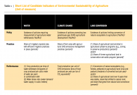
-
Subcounty administrative boundaries in Uganda in 2002
Contact Uganda Bureau of Statistics for an updated version of subcounty boundaries (Data collection from July 1999-March 2002)
-
Uganda Protected Areas as of 2007
Gazetted areas of Uganda as of 2007.
-
Digital Globe GEO1 Satellite Imagery
Effective emergency planning and response requires quick and easy access to accurate, up-to-date information. DigitalGlobe’s FirstLook is an online subscription service for emergency management that provides fast web-based access to pre-and post-event imagery of world disasters delivered to...
-
Digital Globe QB01 Satellite Imagery
Effective emergency planning and response requires quick and easy access to accurate, up-to-date information. DigitalGlobe’s FirstLook is an online subscription service for emergency management that provides fast web-based access to pre-and post-event imagery of world disasters delivered to...
-
Digital Globe WV01 Satellite Imagery
Effective emergency planning and response requires quick and easy access to accurate, up-to-date information. DigitalGlobe’s FirstLook is an online subscription service for emergency management that provides fast web-based access to pre-and post-event imagery of world disasters delivered to...
-
Featured RSPO Palm Oil Mills
Certification of sustainable palm oil production is handled through the palm oil mill and its supply base. The certification includes plantations managed by the mill and plantations managed by other suppliers, including smallholders. To have its oil mill certified, a palm oil producer must show a...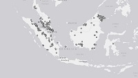
-
Romania tree cover
Retrieved from Global tree cover loss data from GFW. Displays tree cover loss in the country from 2001 to 2013, represented by pixel values 1-13, respectively.