-
Climate Watch Pathways (previously CAIT - Emissions Projections)
The CAIT Projections module was made available in 2015 and provided ready access to emission projections for major emitters through the year 2100 (if data is available). All data is now available on Climate Watch. In addition to providing emissions data, this tool aims to increase the...
-
Climate Watch - U.S. States Greenhouse Gas Emissions
Climate Watch Historical GHG Emissions module enables data analysis by allowing users to quickly narrow down by year, gas, state, and sector. Automatic calculations for percent changes from prior year, per capita, per GDP, and cumulative number across years are also available. Users are presented...
-
Climate Watch (CAIT) - UNFCCC Annex I GHG Emissions Data
The CAIT Paris Contributions Map was made available in 2014 to enables users to explore, compare, and assess countries climate committments in each country's Intended Nationally Determined Contributions (INDC). Countries are not submitting and updating their national climate committments through...
-
Climate Watch (CAIT) - Country Greenhouse Gas Emissions Data
The dataset applies a consistent methodology to create a six-gas, multi-sector, and internationally comparable data set for 197 countries. It enables data analysis by allowing users to quickly narrow down by year, gas, country/state, and sector. Automatic calculations for percent changes from...
-
Aqueduct Global Maps 2.0
Companies can use this information to prioritize actions, investors to leverage financial interest to improve water management, and governments to engage with the private sector to seek solutions for more equitable and sustainable water governance. Aqueduct Global Maps 2.0 includes indicators of...
-
Featured Climate Watch – Nationally Determined Contributions (NDC) Data (previously CA...
The CAIT Paris Contributions Map was made available in 2014 to enables users to explore, compare, and assess countries climate commitments in each country's Intended Nationally Determined Contributions (INDC). Countries are not submitting and updating their national climate commitments through...
-
CAIT Indonesia Climate Data Explorer (PINDAI) Data
The data set draws primarily from Local Action Plan for Greenhouse Gas Emission Reduction (RAD GRK), and Medium Term Local Development Plans (RPJMD) of each province in Indonesia. These documents are obtained from Indonesian national and regional government agencies, including the Secretariat of...
-
Climate Vulnerable Forum Mapping of Opportunities
This data maps opportunities for Climate Vulnerable Forum countries to enhance their Nationally Determined Contribution by 2020.
-
CAIT - Countries' Pre-2020 Climate Pledges submitted to the UNFCCC
The structured data from the CAIT Pre-2020 Pledges Map enables users to explore, compare, and assess climate change mitigation pledges submitted by Parties to the United Nations Framework Convention on Climate Change (UNFCCC) in 2009 and 2010. The information related to quantified economy-wide...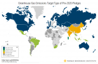
-
Reefs at Risk Revisited: Climate-Related Threats Data
Global (i.e., climate-related) threats to the world's coral reefs were analyzed. These include: past thermal stress (i.e., warming seas and bleaching over the last decade), future thermal stress (ie., projections of future warming in 2030 and 2050); and ocean acidification (i.e., reduced ocean...
-
Datasheet for Technical Note: A Breakdown of Developed Countries’ Public Clim...
This dataset contains a breakdown of developed countries individual public contributions in public climate finance towards the $100 billion commitment between 2013-2018. This dataset was used in WRI’s technical note ‘A Breakdown of Developed Countries’ Public Climate Finance Contributions Towards...
-
CAIT - Country Clean Technology Data
This collection emerges from a collaboration of five leading research institutions: World Resources Institute (WRI), Institute for Global Environmental Strategies (IGES), Öko Institut, Renmin University, and The Energy and Resources Institute (TERI), based in the target countries. Researchers at...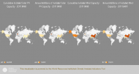
-
Fast-Start Finance Contributions
This workbook contains data from a detailed review of the 2010-2012 fast-start finance (FSF) contributions of five countries reporting the largest FSF contributions (Germany, Japan, Norway, the UK, and the USA) and from a supplemental review of the remaining FSF contributions from 31 additional...
-
Índice de Desigualdad Urbana (Index of Urban Inequality)
The main objective of the UII methodology is to estimate the level of accessibility/proximity to urban equipment for different socioeconomic strata in cities. This allows to compare and identify inequality in the territorial distribution of development opportunities such as formal employment,...
FORMATS: -
Featured Global Power Plant Database
The Global Power Plant Database is a comprehensive, open source database of power plants around the world. It centralizes power plant data to make it easier to navigate, compare and draw insights for one’s own analysis. The database covers approximately 35,000 power plants from 167 countries and...
-
China Overseas Finance Inventory Database
The COFI database includes power-generation projects in Belt and Road Initiative (BRI) countries financed by Chinese corporations and banks that reached financial closure from 2000 to 2023. Types of financing include debt and equity investment, with the latter including greenfield foreign direct...
-
Locations of water supplies serving Nairobi, Kenya.
Locations of dam were approximately located by WRI based on SoK 1971, MoWD and JICA 1992a, 1992b, 1992c, Nyaoro 1999, and Wambua 2003. This data was used in Map 3.9 in Nature's Benefits in Kenya: An Atlas of Ecosystems and Human Well-Being.
-
Marine Protected Areas in Coral Reef Regions of the World
This dataset is part of the base data used for Reefs at Risk Revisited. To assess the level of protection and management for coral reefs around the world. The map of MPAs and associated management effectiveness scores were used to adjust pressure from overfishing and destructive fishing in the...
-
Supplementary Materials for "State of the Nationally Determined Contributions...
This dataset presents information on the adaptation components of 86 countries’ NDCs submitted until June 30, 2021, in association with the working paper State of the Nationally Determined Contributions: Enhancing Adaptation Ambition. Nine NAPs submitted by the 86 countries during this time frame...
-
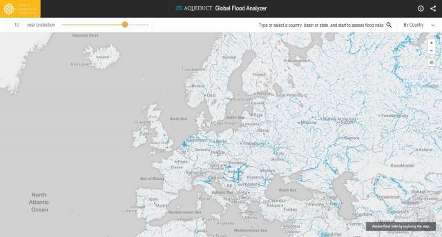
Featured Aqueduct Global Flood Risk Maps
For the current scenario, we used hydrological data from 1960 through 1999 for generating flood inundations for 9 return periods, from 2-year flood to 1000-year flood, and 2010 GDP, population, and land use data for assessing flood impacts. For future projections, we used 5 GCMs (Global Climate...